Severe thunderstorms capable of producing damaging winds and a tornado or two remain possible later this evening as a cold front moves through the Upper Cumberland.
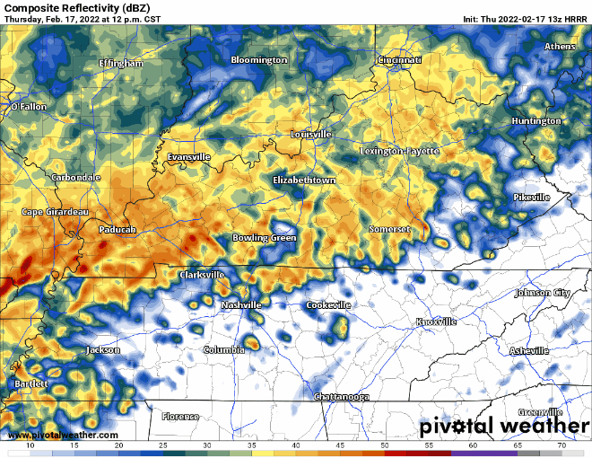
Off and on showers and thunderstorms will be scattered about throughout the day, as we’ve already seen this morning. This activity isn’t expected to become severe as the atmosphere isn’t quite primed for strong storms just yet.Wind gusts will remain strong throughout the day, even outside of storms.
A Wind Advisory remains in effect through 9 p.m. this evening for the entire region for sustained winds of 15 to 30 mph with gusts in excess of 45 mph possible at times.
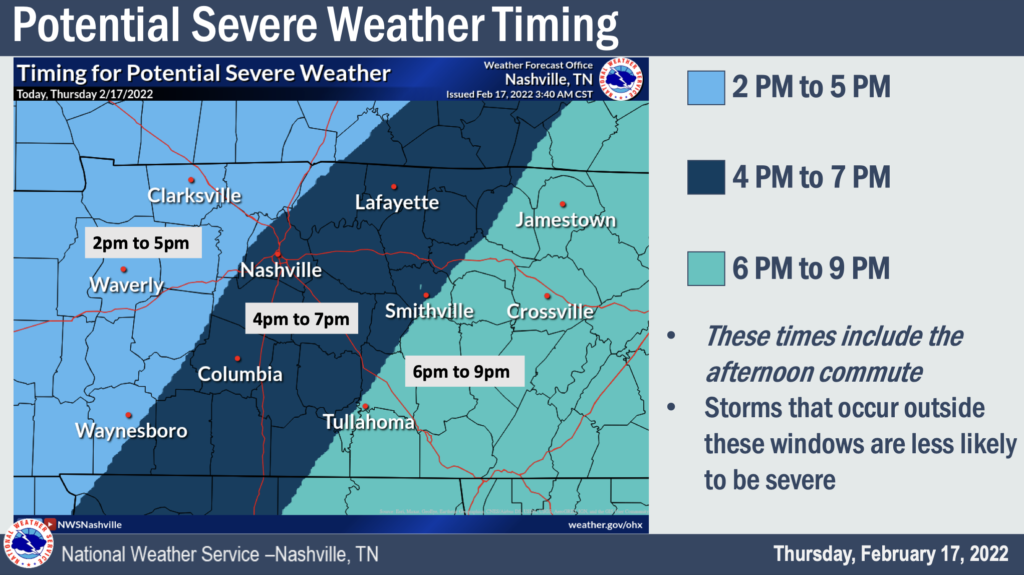
The main storm line looks to knock on our door later this evening. I’ve listed out some ETAs below. Please note that this will be a fast-moving line and will only take a couple of hours to roll through the entire region. These are just estimated start time windows.
4-7 p.m. – Clay, DeKalb, Jackson, Macon, western Overton/Putnam, Smith and Trousdale Counties
6-9 p.m. – Cumberland, Fentress, eastern Overton/Putnam, Pickett and White Counties
We may see rain and storms out ahead of the main line. Models seem pretty keen on this storm line coming at the tail-end of our storminess today as the cold front itself moves through this evening.
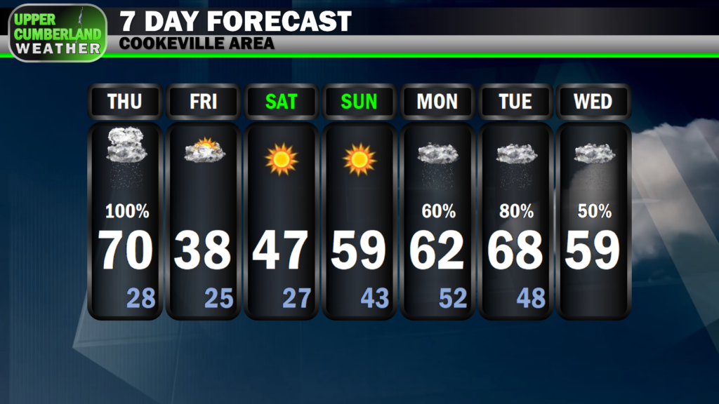
A steep drop in temperatures will follow once the main storm line passes through your area this evening. We’ll fall all the way down into the upper 20s by Friday morning; however, no snow is expected as moisture will quickly move out before temps fall below freezing.
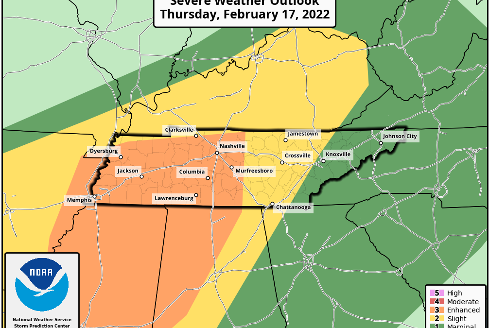
Regarding our severe storm threats, all areas are under the gun for potential damaging, straight-line wind gusts, potentially in excess of 70 mph. An isolated tornado or two also can’t be ruled out — that threat being greater the farther west you are (see the maps below).
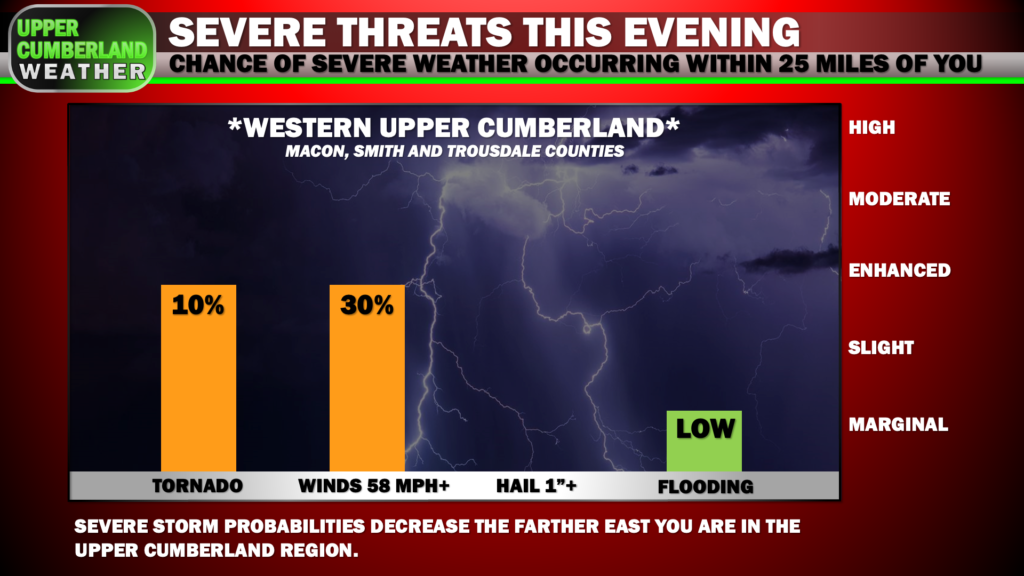
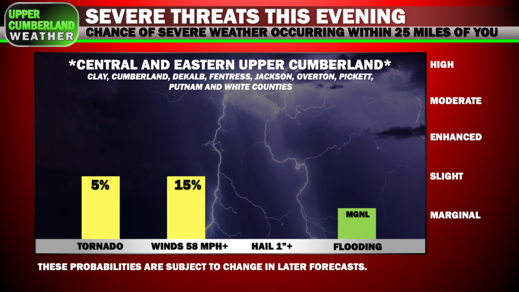
Localized flash flooding can’t be ruled out, but the threat is quite low. We’re not expecting any hail with this system, either.
To summarize, scattered showers and thunderstorms will be with us throughout the day. Our primary strong/severe storm threat won’t arrive until the cold front knocks on our door this evening, dragging with it what will likely be a QLCS (squall line).
Stay weather-aware as we go through the day. Make sure you are able to receive alerts should a warning be issued for your location.
Important to note: YOU *WILL NOT* HAVE MUCH TIME TO REACT should a Tornado Warning be issued for you location. The fast movement of these storms won’t allow for very much lead time, especially if a tornado quickly develops.
Have your plan in place and know where you will go. If you live in a mobile home, your best bet is to make arrangements NOW to ride the storms out at a neighbor, friend or family’s member’s place until the storms pass.
Even straight-line winds can cause weak tornado-like damage, especially in this environment where 70 mph+ winds are possible.
My advice is to treat Severe Thunderstorm Warnings today as you would Tornado Warnings and head to you safe spot. It won’t hurt to do so.
We’ll have updates posted throughout the day to our Facebook and Twitter and will go live with coverage on either of those platforms and our Youtube channel should any warnings be issued for any part of our coverage area.