
A low pressure system spinning along near the Gulf of Mexico will bring showers to much of Alabama and Georgia today as it moves toward the east. The main influence we’ll see from this system up here in the Upper Cumberland will be a fairly persistent deck of cloud cover.

A few passing sprinkles can’t be ruled out through this afternoon, mainly across areas along and south of I-40. The best chance of sunshine filtering through the clouds will be in areas north of I-40, closer to the Kentucky border.

As the low pressure system to our south slides east, cloud cover will begin to break up with sprinkle chances ending. Overnight lows will be chilly but seasonable for this time of year in the upper 20s to around 30°.

A dry cold front will also move through overnight, setting us up for a cold Wednesday with highs only reaching the lower 40s even with a plethora of sunshine.
The cold temperatures will be long-gone come Christmas Eve-Eve (Thursday) as we return to a southerly pattern allowing milder temperatures to flow back into the Mid State. Highs will span the 50s area-wide — perhaps nearing 60° in a few locations west of the Plateau.
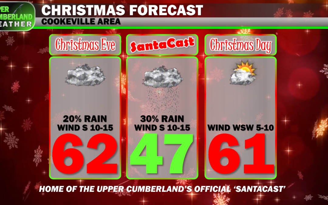
Of course, everyone wants to know about Christmas…

It’s well-established by now that this most certainly won’t be a ‘white Christmas’ (we don’t see too many of these anyway, so this doesn’t come as any real surprise).
Mild temperatures in the lower 60s can be expected both Christmas Eve and Christmas Day. This meets my personal requirement for ‘shorts on Christmas,’ but your attire preferences may vary.
We’ll also see a disturbance pass through that may bring a few light showers to the area Christmas Eve through Santa’s arrival that night, but it’s not looking like these will cause too much of a stir.
As for Christmas Day, we’ll keep the rain chance out for now, but we can’t rule out some of that light shower activity lingering around a while longer. The good news is this will just be rain. No storms are expected.
