
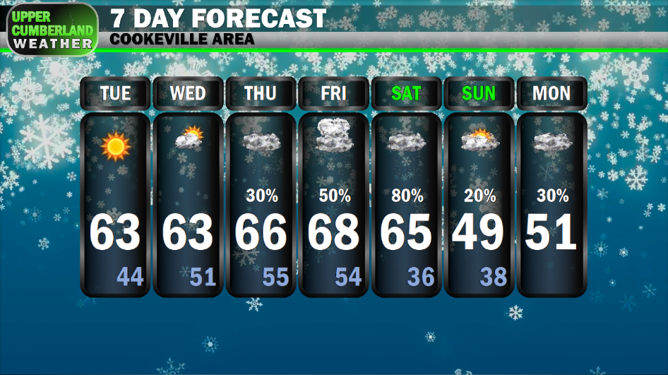
Temperatures are beginning to creep back up following our weekend cold front thanks to warm air advection out of the south.

Many areas will see highs top out in the lower 60s today under a mainly sunny sky. That’s a good 10-15 degrees above our seasonable average for this time of year.
Overnight lows will get a boost, as well. We won’t be quite as chilly tonight with lows only falling off into the lower to middle 40s.

A few more clouds may be present in the sky Wednesday ahead of our next weather system, but we’re still expecting plenty of sunshine and highs similar to today in the lower 60s (around 60 on the Plateau). Overnight lows may even be above our normal *high* temperatures for this time of year in the 50s.
A frontal boundary will begin to approach the mid state late in the week, stalling out as a stationary boundary and bringing potentially multiple rounds of rain and a few thundershowers into Saturday.

Even with temperatures expected to warm further into the middle to upper 60s, we’re not expecting any severe weather at this time as the right instability dynamics don’t look to be in place.
Rainfall amounts Thursday through Saturday are forecast to range from about 1-2 inches — higher totals being more likely across our northwestern zones with lesser amounts the farther southeast you are.

We’ll likely see some breaks in the rain, so it shouldn’t be a total washout heading into the weekend. We’ll have a better idea for *when* it might rain as we get closer to time, but for now, it might be wise to go ahead and plan around rain for any outdoor events scheduled.
A cold front looks to bring a reinforcing shot of cold air into the Upper Cumberland by Saturday night, potentially setting us up for a few snow showers.
With overnight lows expected to be at or above freezing, this would likely be a ‘splat, then melt’ type situation. If anything did manage to accumulate, it won’t stick around very long at all, especially with highs Sunday forecast to top out in the middle 40s to around 50°.
Looking ahead to the week of Christmas, it’s hard to give any sort of forecast that isn’t complete voodoo this far out. That said, I’m not seeing anything at least in the last few runs of the GFS model that would suggest a ‘white Christmas,’ but we’ll certainly be watching the forecast closely to see what happens.
For what it’s worth, the 8-14 day outlook from the Climate Prediction Center is calling for above average temperatures to continue through Christmas with near average precipitation chances. This doesn’t mean temperatures can’t meander from warm to cold allowing for snow, but there is an increased probability we will see above average temperatures for an extended period.

