
(Re-post from Facebook)
We continue to monitor the possibility of severe weather later this afternoon and evening.
Widespread rain and thunderstorms are currently ongoing across much of the Upper Cumberland. These are of little to no concern. We are managing to generate at least some lightning, but instability needed to produce severe storms is near zero. It won’t rise until later this afternoon.
As we move into the afternoon hours, forecast models show their imperfections, as there still isn’t a clear cut solution as to when storms can be expected.
If we listen to the HRRR model, it tries to bring a squall line through the Upper Cumberland between 6-9 p.m. as the ‘main event’ — only a few residual showers thereafter until the cold front passes later tonight. That squall line could contain damaging, straight-line wind gusts and large hail; however, the tornado threat will be very low as not all ingredients to support a tornado threat will be in place. This line would impact all areas.
If we listen to the NAM3km model, that main event line holds off until later tonight, essentially developing right on top of the Plateau between 9 p.m. and midnight — completely ignoring those west of Cookeville (I don’t think those west of Cookeville will escape this day storm-free, but the NAM3 sure seems to think so). This line would be the ‘main event’ and also present a damaging wind and large hail threat, although conditions might be a bit more favorable for isolated tornadoes at that point.
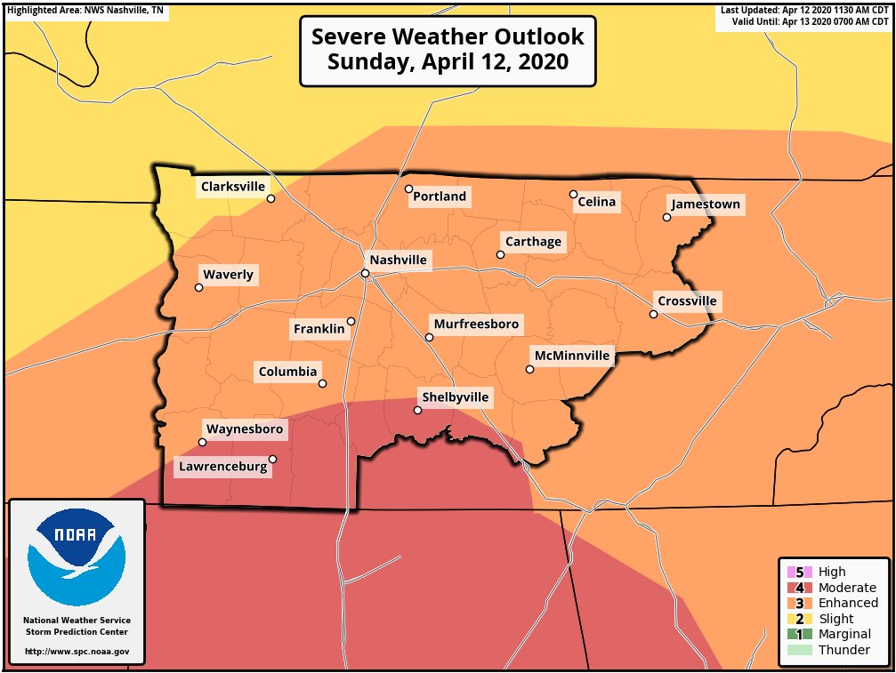
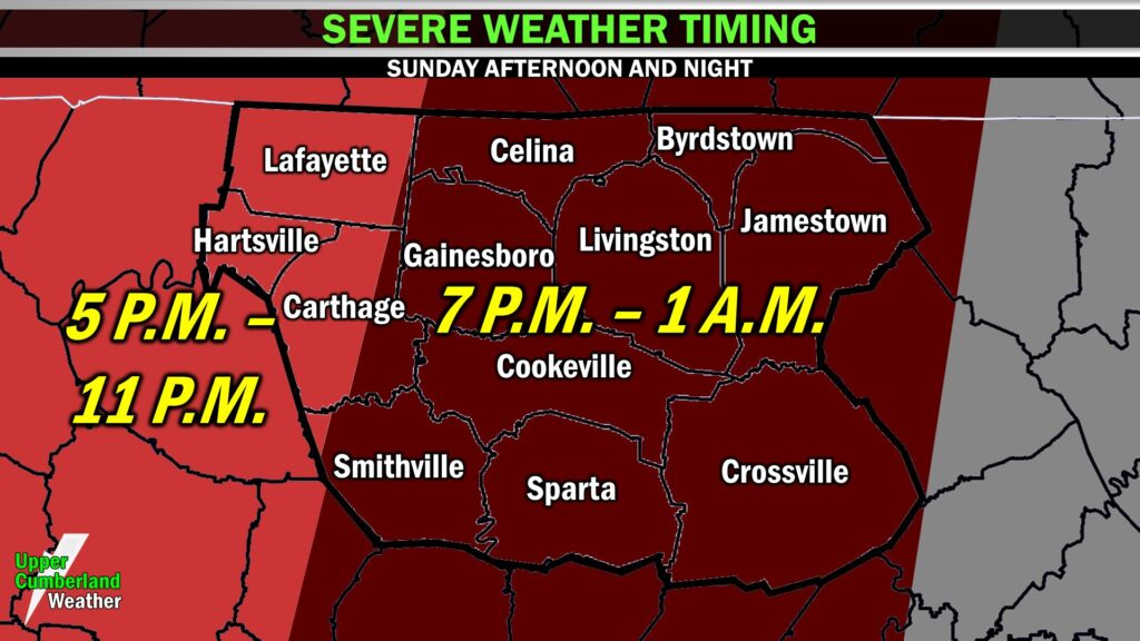
One of these models could be on to something. Both models could be dead wrong. For that reason, we’re keeping the window for potential severe weather pretty wide open, 5 p.m. through 11 p.m. for our NW areas, 7 p.m. to 1 a.m. for the majority of the region east to the Plateau (I won’t be answering timing questions since we have the graphic below, so consult with that graphic for your county/community — also note that it won’t storm that entire time, this is just the window for when storms will happen at some point).
If and when strong storms do present themselves, wherever that may happen this evening, damaging winds and large hail will be our main concern. An isolated tornado or two cannot be ruled out, but that threat will be largely dependent upon timing and instability, and both are a bit up in the air right now.
The good news is that the rains we’re seeing now are helping to keep the atmosphere stable. The more rain we see throughout the afternoon, the less instability will be able to infiltrate the area. That said, there is a substantial amount of wind shear in place, and it won’t take much to at least generate straight-line winds with storms that form this afternoon and especially evening.
The bad news is that it’s going to rain A LOT. As much as 2-3 inches of rainfall can be expected through early Monday morning with locally higher amounts possible. A Flash Flood Watch is in effect for the entire region (Macon County was added this morning) through Monday morning. Those in low-lying, flood-prone areas should be on alert.
In addition to flooding, winds will pick up substantially this afternoon and evening. A Wind Advisory is in effect through early Monday morning — winds will be sustained at 15-25 mph with gusts to 45 mph likely. With the ground being saturated, non-thunderstorm wind gusts will likely be sufficient to down a few trees.
Stay weather-aware as we go through the day and have multiple ways of receiving storm alerts should a warning be issued for your location. We’ll be live here providing updates as needed throughout the event, and our radar live stream will be available all day to reference.