Five years ago (holy cow, it’s been five years??), I decided to start posting a daily weather blog back when this was Smith County Weather . The blog would take on various forms and locations — ran intermittently around my personal schedule with no real plan for what it would look like in the future — but at the end of the day, it was ultimately dissolved.
I believe the last blog update probably came in, what, late 2017?
I don’t remember, quite honestly. It’s been a while.
Today, following a lengthy hiatus, I am bringing the blog back.
Truly, I don’t know how much different things will be now than they were in the past. I would like for the blog to be updated as close to daily as possible, but there may be times it is reserved mostly for severe weather.
At the end of the day, our focus is on our social media. The website is secondary, but I do believe it is necessary.
Anyway, I can explain all of the nuances of our website at a later time and in a different location. For now, let’s focus on the weather.
Yesterday brought some of us quite a random scare. A pair of Tornado Warnings were issued for Overton and Fentress Counties, respectively.
At the time the warnings were issued, the Storm Prediction Center only had the Upper Cumberland outlooked for ‘general’ thunderstorms. Severe weather wasn’t much of a concern.
That said, a supercell managed to form late in the morning that tracked almost due east across Smith and Jackson Counties. By the time the storm reached Overton County, it was showing signs of rotation aloft. As the rotation couplet on radar tightened, the National Weather Service office in Nashville opted to issue a Tornado Warning for the storm.
I went live for both that warning and the one that followed in Fentress County. Fortunately, no tornadoes or damage were reported, but this does serve as a reminder that we are very much into our spring severe weather season, and even the most benign-appearing thunderstorms days can’t be ignored completely.
While on the subject of severe weather, we do have a threat coming up on Tuesday. More on that down below.
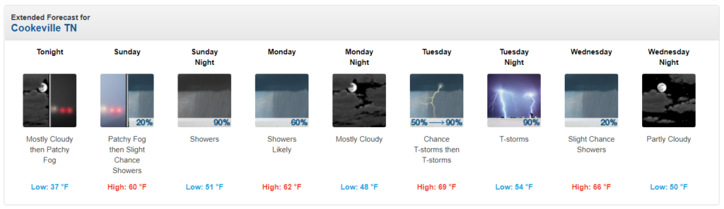
Today has been a bit chillier than what we’ve grown accustomed to the past few days, but this cold spell won’t last. Following a mild day tomorrow in the upper 50s to lower 60s, we’ll gradually warm into the 70s this week in many spots.
A few scattered light rain showers will become possible throughout the day on Sunday with better chances arriving overnight Sunday into Monday morning. We may see a break in rainfall Monday afternoon before a warm front lifts north through the area Monday night into Tuesday morning, bringing additional showers and thunderstorms into the region, some storms of which could be strong.
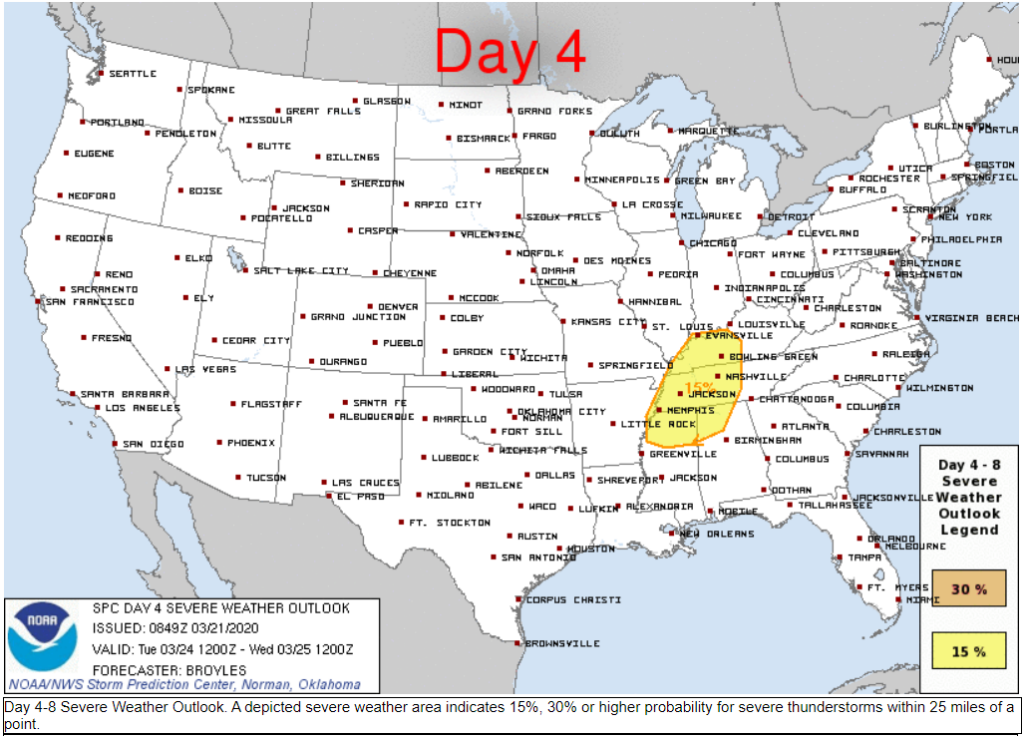
Tuesday will see a potent storm system move into Middle Tennessee with strong to severe thunderstorms possible as early as morning; however, our primary severe storm threat looks to come during the afternoon and evening hours.
Details at this point are still a bit sketchy, but it does appear enough ingredients will be in place to generate a damaging wind and tornado threat on Tuesday.’
From NWS Nashville’s area forecast discussion:
Another brief break in the rainfall will come Monday afternoon
into Monday evening. Then showers will return late Monday night
as a more potent system approaches from the west and lifts a warm
frontal zone northward across the area. This fast moving system
will generate a surface low pressure just to our northwest,
setting the stage for a stormy Tuesday. Cape values will increase
into the 500-1000 range, and perhaps higher if there is more than
expected sunshine. Forecast soundings show very strong deep layer
shear over 50KT and impressive low level SRH values that would
support severe storms with damaging winds and possible tornadoes.
The main time will be Tuesday afternoon and evening, but storms
could ramp up as early as Tuesday morning along the warm front.
Definitely a day for concern, and you will want to check back for
updated outlooks.
Tuesday is a day we will certainly want to pay attention to.
Extended Forecast: