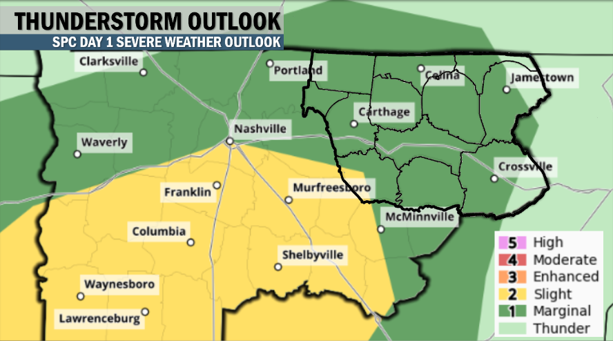
UPDATED AT 2:15 P.M. CST – The Storm Prediction Center has moved the Marginal Risk for severe weather to now encompass pretty much all of the Upper Cumberland — also introducing a Slight Risk (level 2 out of 5) just to our SW and barely encompassing DeKalb County.
Thunderstorms have already developed and are moving through areas primarily along and north of I-40 this afternoon. The hope is that these storms will help work over the atmosphere some, depleting some of the available energy tonight’s storms will need to be strong, but there are no guarantees. For that reason, the Marginal Risk will be in effect through this evening.
From here, the forecast hasn’t changed much, so we resume the earlier forecast post, already in progress:
A cold front will move through Middle Tennessee late this evening. That front will drag with it a line of heavy showers and thunderstorms sometime between supper and bedtime (maybe a little later for those on the Plateau).
The overall severe weather threat is on the low side (Marginal Risk), and again, that threat is mainly focused on our northern and western areas where instability (while low) will be a bit more supportive of strong storms.
CAPE (convective available potential energy) values, otherwise known as ‘storm fuel’, looks to be low. That said, the more breaks in cloud cover we see and the more temperatures are able to rise during the afternoon, the more energy will be available for storms to feed off of.
We’ll also have plenty of wind shear for storms to tap into, and you’ll be able to notice it as we go through the day with winds gusting as high as 20 mph+ at times (just below Wind Advisory criteria).
For those reasons, our primary threat this evening will be damaging wind gusts as well as large hail (again, both threats are low…can’t stress that enough). There is also a risk of an isolated tornado developing, but that threat is very low.
SPC has broken out the risks as follows (all % are chance of severe weather occurring within 25 miles of your location):
Damaging Winds: 5%, Large Hail: 5%, Tornado: 2%
These threats decrease the farther east you are, although even those outside of the Marginal Risk area should still at least remain aware that storms are coming this evening, and a stray severe storm can never be fully ruled out.
Here’s how the HRRR sees the line moving through this evening:
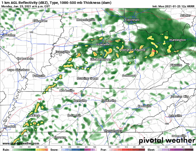
The timing for this line to arrive looks to be between 8 p.m. and midnight from west to east, give or take an hour.
Once the line passes, our severe weather threat (which is already low) will end.
And despite this being a cold front, we really won’t cool down too much.
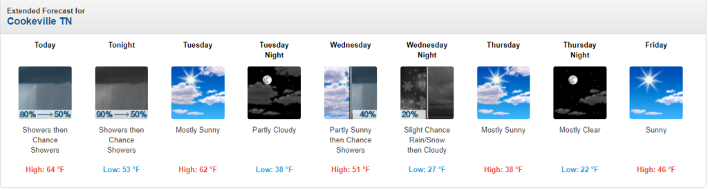
Highs tomorrow still look to top out in the middle 60s in many areas under a mostly sunny sky, so get out and enjoy it!
Another cold front will move through late tomorrow — this time with no precipitation expected. This will knock our highs back down into the upper 40s to around 50° on Wednesday — even colder on Thursday with some locations not getting out of the upper 30s!
We’ll also look for yet another system on Wednesday to perhaps end as a little bit of light snow late Wednesday night, especially for the Plateau. Too early to tell if anything will accumulate.