
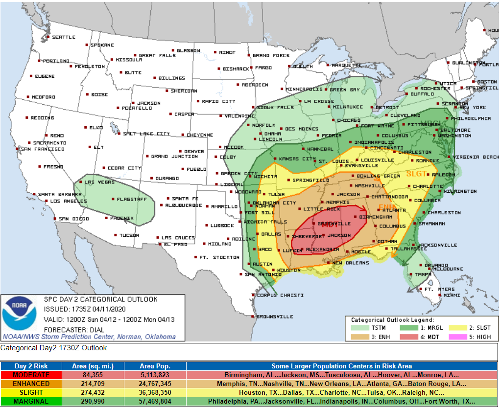
Confidence remains pretty high that much of the Southeast will be dealing with severe weather on Easter (tomorrow).
We’re enjoying a spectacular afternoon today, and (provided you follow proper ‘social distance’ guidelines) you should absolutely get out and enjoy it!
That said, don’t let this nice weather fool you, as tomorrow will look drastically different with widespread rain and storms likely, including the threat of severe weather during the afternoon and nighttime hours.
If you have an Easter egg hunt planned for tomorrow, try to move it to today if possible or plan to host it indoors tomorrow.
Many churches are planning outdoor services Easter morning. Indications are the morning hours will be rainy, and a few rumbles of thunder can’t be ruled out, so prepare accordingly. The likelihood of severe storms appears to be on the low side morning through midday, but do have a plan in place to take shelter should severe weather interrupt your service.
A note to rural churches: some areas have limited or no cell service. Make sure you have a secondary means of receiving alerts in the off-chance a warning is issued in the middle of preaching from the gospel of Luke.
Let’s go through a breakdown of what we’re expecting tomorrow and where uncertainties exist.
MORNING HOURS (PRE-CHURCH):
Widespread will begin infiltrating the region. We could experience some embedded lightning, and winds will be on the increase as the low pressure gradient moves closer to Middle Tennessee. Severe weather concern at this point is low.
MIDDAY (CHURCH AND LUNCHTIME):
Rain and thunder may still linger around. Winds will really start to become breezy, perhaps approaching the 15-20 mph mark. Instability may begin to increase a bit as a warm front approaches, but the severe threat still remains on the lower side. We should be paying close attention to the weather at this point for what may come during the afternoon.
AFTERNOON (YOU’VE EATEN YOUR CHICKEN, TAKEN PICTURES AND ARE NOW SETTLING IN):
This is where forecast models differ. The center of low pressure is either aiming to set up somewhere over northwestern Middle Tennessee near Clarksville, or it’s heading farther north toward somewhere between Cape Girardeau and St. Louis in southeastern Missouri.
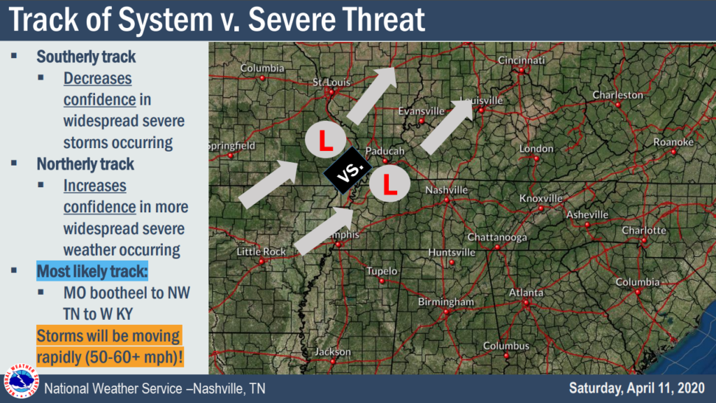
Scenario 1 (low confidence but high impact): The low ends up tracking somewhere close to Missouri. The warm front fully lifts north through Middle Tennessee, and the widespread rain showers break apart/move up into Kentucky, introducing some sunshine to the region and allowing instability to increase substancially.
If Scenario 1 plays out in full, we will be looking at a severe weather risk much more akin to what Louisiana, Mississippi and west-central Alabama are facing with widespread severe weather, including tornado-producing supercells.
Again, confidence in Scenario 1 is very low right now, and only a few models are hinting at this.
Scenario 2 (a bit more confidence and lesser impact): The lows tracks closer to us. Widespread showers and some thunderstorms persist across Middle Tennessee throughout the afternoon, greatly limiting instability as the warm front take its time getting here.
If Scenario 2 plays out in full, the really nasty severe weather stays well south and west of us during the afternoon hours. A stronger storm or two still cannot be ruled out, but our main threat won’t come until later at night.
Most models seem to be favoring Scenario 2 at this time, but this could change as time goes on.
EVENING AND NIGHTTIME HOURS (JUST ATE SOME LEFTOVER CHICKEN AND GETTING READY FOR BED):
The cold front will be on approach to Middle Tennessee. By this point, the warm front has lifted through and most showers have probably decreased in coverage, allowing instability to finally move in.
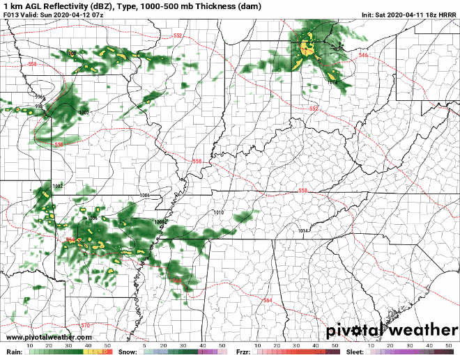
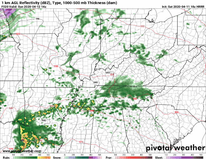
That front will likely generate a QLCS (quasi-linear convective system, AKA ‘squall line’) that will move through during the late night hours — at least as it appears right now.
Regardless of whether we see any severe weather during the afternoon or not, the nighttime storm threat has much higher confidence and will need to be monitored closely.
All modes of severe weather will be possible with this storm line — damaging winds of 60 to 70 mph (locally higher gusts possible), large hail one inch in diameter (or larger) and even a few isolated tornado spin-ups.
Timing for when we can expect this storm line to move through is depicted below:
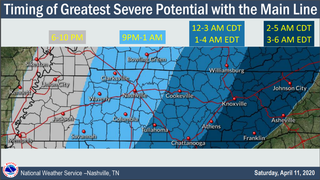
Once that line clears the region, our severe weather threat will end.
So to recap, we have two potential shots at severe weather: afternoon and nighttime. The afternoon threat is very much up in the air and contingent upon multiple factors. The nighttime threat has high confidence and will likely come to fruition. Exacting ETAs are unknown, and should we see afternoon severe storms flare up, we won’t know when or where they will occur until we can see them on radar. “Afternoon hours” is the best and only ETA that can be given right now. The nighttime line of storms is a bit more tangible, so we can give some sort of estimate as to when those storms can be expected (see timings above).
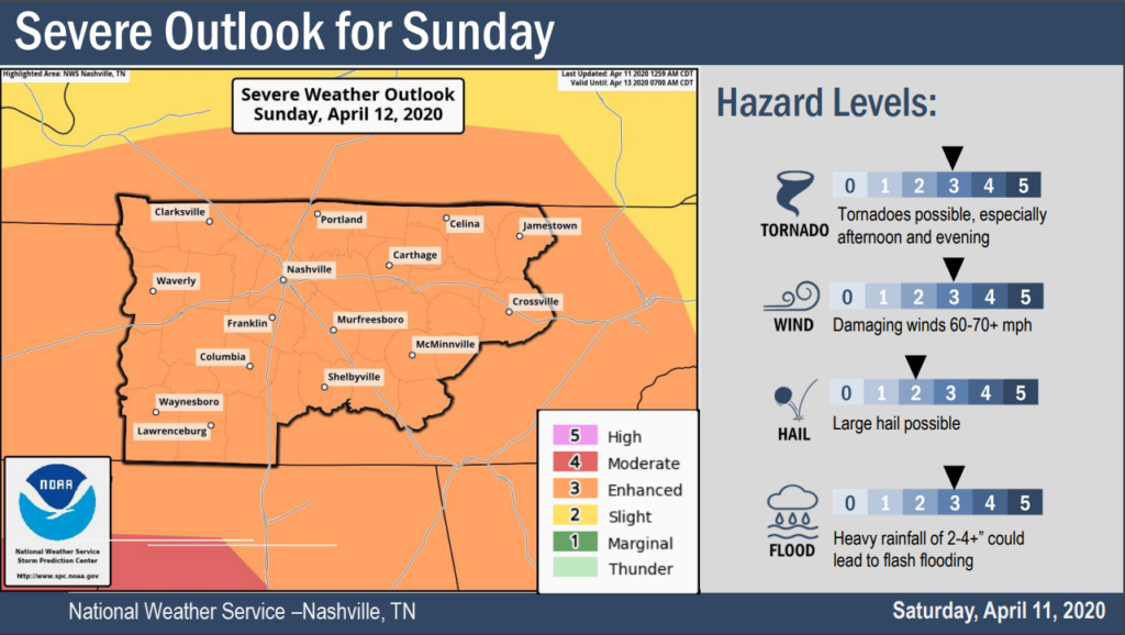
Since it hasn’t already been stated at this point, the entirety of the Upper Cumberland is included in an Enhanced Risk for severe weather tomorrow by the Storm Prediction Center.
Severe weather risks are as follows (within 25 miles of any given location)
- Damaging Winds: 30%
- Large Hail: 15%
- Tornadoes: 5%
In addition to the threat of severe weather, we are also paying close attention to the rainfall forecast.
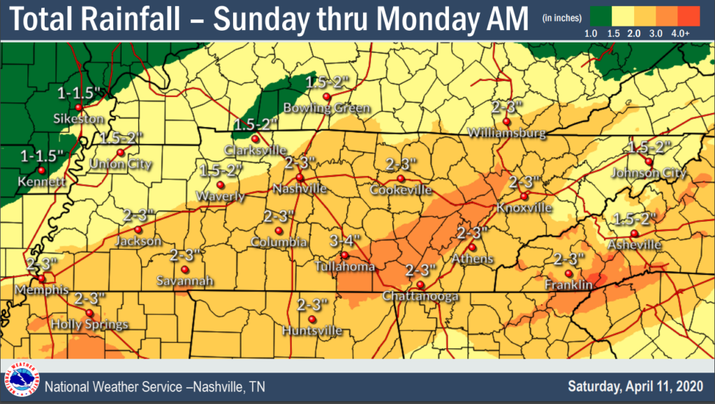
Total rainfall amounts Sunday through Monday morning look to be in the 2-3 inch range with locally higher amounts possible.
Some storms could contain high rainfall rates, leading to the potential for flash flooding. Those in low-lying areas near creeks and streams should pay close attention to this threat tomorrow.
Finally, winds will become quite gusty as we go through the day. NWS Nashville has mentioned that a Wind Advisory might be warranted tomorrow, with non-thunderstorm wind gusts of 40-50 mph possible throughout the afternoon and evening.
Make sure you are prepared for tomorrow. This is a dynamic storm system with many variables that can and will change between now and tomorrow.
Fully charge your cellphones tonight and make sure they are charged throughout the day tomorrow. Download weather alerts apps that will sound alerts for warnings issued for your specific location. Ensure your ringer is turned all the way up and ‘do not disturb’ is disabled.
If you don’t already own a NOAA Weather Radio, invest in one if at all possible.
Don’t rely on tornado sirens alone, especially indoors. They are not meant for indoor purposes.
Consult with multiple reliable weather sources and stay weather-aware. We will have continuous updates posted to our Facebook and Twitter pages and provide live coverage on our live stream if and when any warnings are issued.